Back Heerhugowaard Afrikaans Heerhugowaard AN هيرهوخوفارد Arabic Heerhugowaard Breton Heerhugowaard Catalan Gemeente Heerhugowaard CEB Heerhugowaard German Heerhugowaard Esperanto Heerhugowaard Spanish Heerhugowaard Basque
Heerhugowaard | |
|---|---|
City | |
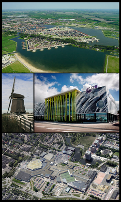
 Images from top, left to right: Stad van de Zon, Veenhuizer wind mill, Cool theatre, shopping centre Middenwaard. | |
 Location of the former municipality of Heerhugowaard in North Holland | |
| Coordinates: 52°40′N 4°50′E / 52.667°N 4.833°E | |
| Country | Netherlands |
| Province | North Holland |
| Municipality | Dijk en Waard |
| Area | |
| • Total | 39.99 km2 (15.44 sq mi) |
| • Land | 38.21 km2 (14.75 sq mi) |
| • Water | 1.78 km2 (0.69 sq mi) |
| Elevation | −3 m (−10 ft) |
| Population (January 2021)[3] | |
| • Total | 58,387 |
| • Density | 1,528/km2 (3,960/sq mi) |
| Demonym(s) | Heerhugowaarder (Informal) Reiger |
| Time zone | UTC+1 (CET) |
| • Summer (DST) | UTC+2 (CEST) |
| Postcode | 1700–1705 |
| Area code | 072 |
| Website | www |
Heerhugowaard (Dutch: [ˌɦeːrɦyɣoːˈʋaːrt] ⓘ; West Frisian Dutch: Heerhugoweard, Heregeweard or De Weard) is a city in the Netherlands, in the province of North Holland and the region of West Friesland.
Heerhugowaard was previously a municipality, which merged with the former municipality of Langedijk into the new municipality of Dijk en Waard on 1 January 2022.
- ^ "Kerncijfers wijken en buurten 2020" [Key figures for neighbourhoods 2020]. StatLine (in Dutch). CBS. 24 July 2020. Retrieved 19 September 2020.
- ^ "Postcodetool for 1703EZ". Actueel Hoogtebestand Nederland (in Dutch). Het Waterschapshuis. Archived from the original on 21 September 2013. Retrieved 6 March 2014.
- ^ "Bevolkingsontwikkeling; regio per maand" [Population growth; regions per month]. CBS Statline (in Dutch). CBS. 1 January 2021. Retrieved 2 January 2022.
© MMXXIII Rich X Search. We shall prevail. All rights reserved. Rich X Search

